THE RISE AND FALL OF THE HAMPSHIRE AND HAMPDEN CANAL
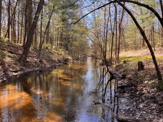
 An intact canal prism of the Hampshire and Hampden Canal in Northampton, Massachusetts.
Once considered the pinnacle of transportation engineering, the Canal Era took the United States by storm during the first half of the nineteenth century. New Englanders saw how the Middlesex and Erie Canals fueled the economic growth of Boston and New York and wanted to continue the prosperity across the area.
Envisioning a northward path to connect the Long Island Sound in Connecticut to the waters of the St. Lawrence River in Canada, businessmen and legislatures set forth to make it happen. By 1835, the Hampshire and Hampden Canal and the Farmington Canal — the Massachusetts and Connecticut segments of the intended large-scale engineering feat — were operating. However, these canals faced significant challenges. Due to severe financial strain, difficult terrain, tough weather conditions, and the uptake of the railroad, the rest of the vision didn’t come to fruition. The Hampshire and Hampden Canal closed in 1845 after less than a decade in operation.
As a regional planning agency for Hampden and Hampshire counties in Massachusetts, the Pioneer Valley Planning Commission’s (PVPC) mission is to preserve and enhance the quality of life for its communities. PVPC selected SWCA to locate, map, and document the Hampshire and Hampden Canal route and its surviving engineering features with the hope of eventual inclusion on the National Register of Historic Places (NRHP).
HISTORIC PRESERVATION: PIECING THE CANALWAY TOGETHER
 An eastern towpath remnant of the Hampshire and Hampden Canal in Easthampton, Massachusetts.
The historic preservation of this canal presented layers of complexity, including the scarce and distributed nature of archival materials, limited mapping resources, urban and suburban development, erosion, dense forests, and private property restrictions across the 30 miles of terrain. The Hampshire and Hampden Canal also winds through six municipalities of Southwick, Westfield, Russell, Southampton, Easthampton, and Northampton, involving many stakeholders and communities.
SWCA assembled a team of specialists in archaeology, anthropology, history, geospatial science, and cultural resources management to best determine the historic course of the canal on the modern-day landscape while adhering to schedule and budget.
“The procedure we employed to document the Hampshire and Hampden Canal is a celebration of blending historical records with cutting-edge technology and local wisdom,” said Chris Donta, senior cultural resources team lead at SWCA. “I’m proud of our team’s ability to combine data, LiDAR technology, aerial imagery, and the insights of historians into a highly accurate representation of this historic marvel.”
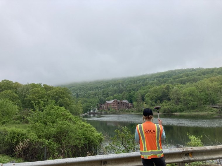
 Nadia Waski, an associate project archeologist at SWCA, collects data of the Hampshire and Hampden Canal in western Massachusetts.
Referencing methodology used to document other historic canals across New England, the SWCA team developed a modern approach to document and map the Hampshire and Hampden Canal for historic preservation. SWCA archaeologists first mapped the predicted route of the former canal. Partnering with our archaeologists and geospatial data experts, SWCA’s field specialists retraced and documented the historic course of the canal and the locations of significant engineering features. The team assessed and confirmed the presence, or what’s now missing, of the canal prism and towpath remnants, along with associated features as they exist in the landscape today.
 SWCA archaeologists document the remnants of the earthworks and stonework of Lock 6 of the Hampshire and Hampden Canal in Southwick, Massachusetts.
Using this data, our GIS experts generated a highly accurate canal route by combining LiDAR data, historical mapping overlays, aerial imagery, and detailed notes from local historians. The SWCA team also completed Massachusetts Historical Commission forms, describing the canal area within the bounds of each of the six townships and the route’s impact on each of those towns. The forms also detailed the physical presence canal engineering had, and still has, on the land. For segments and features lacking any present indications on the landscape’s surface, the team used available resources and methods, including historical resources, previously conducted studies, local historian research, and a general understanding of canal engineering practices, to best plot these elements.
This effort contributes to a NRHP nomination of the Hampshire and Hampden Canal as a significant example of Canal Era engineering in New England.
“We truly appreciate SWCA’s hard work on this project. We started working with the communities on this joint initiative back in early 2020 and it is so exciting to be at this point. We hope to receive a favorable eligibility determination as I believe SWCA has proven that there is still much that remains extant,” said Shannon Walsh, a historic preservation planner at PVPC.
CEMENTING THE CANAL AS A PERMANENT PART OF MASSACHUSETTS HISTORY
 A view of the historic Hampshire and Hampden Canal in Southwick, Massachusetts.
As the evidence and those who know the history of the Hampshire and Hampden Canal are vanishing, PVPC was passionate about documenting the canal’s existing conditions and history in a unified manner.
“The documentation that SWCA put together has exceeded our expectations and, I feel, supports why the communities have fought for documentation and recognition of the Hampshire and Hampden Canal for so long,” said Walsh.
While the PVPC completes the final submission packet to NRHP, the canal route can be accessed on the State of Massachusetts’s mapping portal and used as a planning tool for participating project stakeholders and local municipalities.
Documenting the Hampshire and Hampden Canal will inform future historic preservation of what remains, acknowledge what has been lost, and ensure that the story of this canal becomes a valuable and permanent part of West Massachusetts history.
 Stone abutments from the South Manhan River aqueduct along the path of the Hampshire and Hampden Canal in Southampton, Massachusetts.